ARTICLE BY FANOULA ARGYROU: The deliberate Turkification of Kyrenia through the bizonal map…
Kyrenia was the first victim of the surrender.
In a few weeks, yet another black anniversary of the tragic days of the summer of 1974 approaches, with the coup and the two barbaric Turkish invasions. It was then that the deliberate – on the part of the tragic figures/leaderships in the Republic of Cyprus – ruthless deception of the people of Kyrenia also began, exploiting for years, from balconies and pre-election gatherings, the slogan «Our borders are in Kyrenia».
On 22.12.2016 I wrote the article «Our borders were never in Kyrenia».
https://www.sigmalive.com/simerini/politics/390324/ta-synora-mas-pote-den-isan-stin-keryneia
Kyrenia was the first victim of the surrender. With the deliberate and ruthless deception of the displaced people of Kyrenia by all the party leaders who supported the British-Turkish bicommunal bizonal federation. Starting with Glafkos Klerides, AKEL, Archbishop Makarios, and the rest, with the exception of Spyros Kyprianou (Angela Gillon of the Foreign Office confirmed in 1983 that Sp. Kyprianou HAD NOT ACCEPTED the BBF).
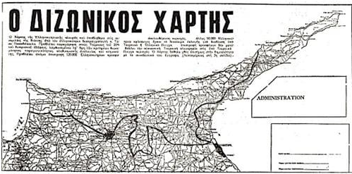
I wrote, at the time, among other things: «When the bizonal map was handed over by T. Papadopoulos to the Turks in Vienna, on 31.3.1977 – which (map) was drawn up by decision of President Makarios (with Vassos Lyssarides and Spyros Kyprianou dissenting at the time) and which was ready in Makarios's drawer when Clark Clifford visited him on 23.2.1977, a revelation by Nelson Ledsky to the British – the British wrote in the Foreign Office about what that map really meant (telegram of 16/4/1977 to Athens, Nicosia, Washington, Bonn, Paris, and the British delegation to NATO):
«We noted the courageous and statesmanlike action of Archbishop Makarios in tabling a map, subsequently published, which made clear to his people the political reality that at least 50.000 refugees could not expect to return to their homes…».
Translation -«We noted the courageous, perceptive action of Archbishop Makarios in tabling a map, which was subsequently published, which made clear to his people the political reality that at least 50,000 refugees should not expect to return to their homes…».
The directives
In an 8-page review of the situation in Cyprus in June 1977, they wrote both about the 4 directives of 12 February 1977 and about the map (in translation):
«The meeting of 12 February 1977 was staged to weaken the general feeling of optimism. Guided by Dr. Waldheim, Makarios and Denktash agreed on written directives for their two negotiators and set the date of 31 March in Vienna, for a series of exchanges of substantive views at the negotiating level…
»The Greek Cypriots handed over a map (31.3.1977 in Vienna) that included only 20% of the Republic (as was made known, it constituted their initial offer – initial bid). However, the mere publication of a map, whose only implication was that many Greek Cypriots -those of the Kyrenia and Lefkoniko region- would never return to their homes, represents an act of great political courage…».
«What is more, even to publish a map, whose clear implication was that many Greek Cypriots -those of the Kyrenia district and Lefkoniko- would never return to their homes, represented an act of considerable political courage…».
Let us now go a little further back in time…
On 21 February 1975 the British confirmed the Turkish launch of large-scale settlement and wrote that the Greek side should no longer expect the return of territory, as Morphou and the surrounding area were being settled, and likewise the new town of Famagusta…
Those insisting on returning were "troublemakers"!
On 22 August 1975 the British wrote that Makarios would accept the Turkish zone being at 25% (it was then that Makarios had already informed the British and Americans that he accepted the BBF but would not say so publicly), he knew that it would divide Greek Cypriot opinion but believed the majority would accept it… Klerides, for his part, estimated that about 80,000-90,000 refugees would return to the areas that the Turks would give back… with the hope that another 40,000 or thereabouts might have the opportunity to return to the north behind the Turkish lines, leaving a mass of insisting troublemakers (obstreperous) numbering some 50,000 or thereabouts (especially the people of Kyrenia) but in any case controllable, to be resettled in the south…
Statistical data on ownership
In August 1975 the Land Registry in Nicosia published data on the real percentages of land ownership across all of Cyprus.
«The real and indisputable facts are that Turkish Cypriot land ownership is 12.3% across all of Cyprus, while Greek Cypriot ownership is 61% and 26.7% does not belong to private individuals… Any claims or assertions by the Turks for a larger percentage of land cannot be supported in any way, unless the Turks drop all their pretenses and say clearly that the Turkish army invaded Cyprus with the sole aim of uniting the occupied areas with Turkey and expanding Turkish territory…
Percentages for Kyrenia and Famagusta
»Turkish ownership in the Kyrenia region was at the level of 12.7% and in Famagusta 12.2%….».
The British High Commission in Nicosia sent the statistics to the official responsible for planning solutions for the Cyprus problem, Miss Moff Fort of the Southern Europe Department at the Foreign Office. With the note that the Land Registry of the Republic of Cyprus is highly reliable and maintains first-class records (Besides, they themselves had created it in 1909 and completed it in 1929).
Our borders were never in Kyrenia from 1974 onward, but this was only for the misleading of the people by everyone and for ruthless vote-chasing to this day.
We do not forget that T. Papadopoulos, by his own admission, during the drawing up of their notorious bizonal map, unilaterally left his own village, Assia, outside the Turkish zone, while they also left the Tympou airport to the Turks…
With their bizonal map they deliberately Turkified Kyrenia and the surrounding region (except for Assia!), so that their deed would be characterized by the moral instigators as an «act of great political courage»…
*Researcher/journalist